Norala: From Humble Beginnings to a 2nd Class Municipality
Norala, South Cotabato, has long been known as a thriving agricultural town, blessed with fertile lands and hardworking people. For decades, it proudly carried the title of the “Rice Bowl of the South”, supplying neighboring areas with rice, corn, and other farm products.
On December 9, 2024, Norala reached a historic milestone when it was officially reclassified from a 3rd class to a 2nd class municipality—a recognition of its steady economic growth, improved local revenues, and the collective efforts of its community.

This achievement not only highlights Norala’s resilience but also reflects the determination of its people to move forward while preserving the warmth and unity that define the town.
✨ Mayad nga Norala! Palanggaon Ta! ✨
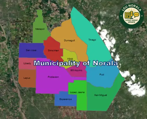
Index Map of Norala Municipality, South Cotabato
Norala as a 2nd Class Municipality
On December 9, 2024, the Municipality of Norala in South Cotabato was officially reclassified from a 3rd class to a 2nd class municipality, a recognition of its economic progress and revenue growth. This milestone marks Norala’s continued development and its growing role as one of the vibrant communities in South Cotabato.
(Source: Public Information Office – Norala, South Cotabato)
Geography and Overview
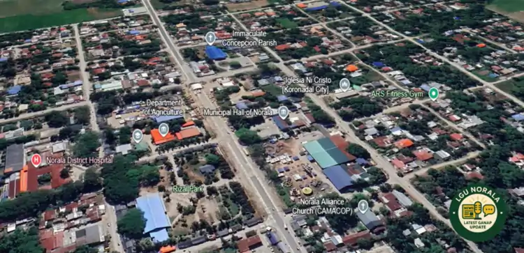
Norala is located in the province of South Cotabato, within the SOCCSKSARGEN region of Mindanao. The municipality has a land area of approximately 188.11 km² and, as of the 2024 census, has a population of 48,499 residents.
The terrain is composed of flat to slightly rolling plains with an elevation range of 81 to 205 meters above sea level. Norala is often referred to as the “Rice Bowl of the South” due to its productive rice lands and agricultural heritage.
Barangay Index and Map
Norala is subdivided into 14 barangays, each marked in the index map with distinct colors for easy identification. These are:
- Benigno Aquino Jr.
- Dumaguil
- Esperanza
- Kibid
- Lapuz
- Liberty
- Lopez Jaena
- Matapol
- Poblacion
- Puti
- San Jose
- San Miguel
- Simsiman
- Tinago

Key Barangay Facts
- Poblacion is the municipal center and the most populous barangay.
- Kibid and Benigno Aquino Jr. have relatively smaller populations.
- Agricultural barangays such as San Miguel, Lapuz, and Simsiman contribute significantly to rice and corn production.
Significance of the Index Map
The index map provides a clear view of Norala’s barangay layout and boundaries, serving as a reference for:
- Local governance and development planning
- Disaster risk reduction and response
- Infrastructure and resource allocation
- Community identity and cultural awareness
Frequently Asked Questions (FAQ)
1. What is the current classification of Norala?
As of December 2024, Norala is officially a 2nd class municipality in South Cotabato.
2. How many barangays are there in Norala?
Norala has a total of 14 barangays, with Poblacion being the municipal center.
3. What is Norala known for?
Norala is recognized as the “Rice Bowl of the South”, known for its vast rice fields, agricultural livelihood, and cultural identity as part of the SOCCSKSARGEN region.
Mayad nga Norala! Palanggaon Ta!
The official tagline of Norala embodies the pride, love, and unity of its people. It reflects the community’s collective vision of progress while holding on to its deep cultural roots.